Sometimes I wish I had that ability to drift into the lane of surrealism. Great & inspiring work!So, this is what happened when I got bored and started a WorldA map with no regard to realism or lore. It was sort of an exercise in just letting my imagination drift wherever without inhibitions. Featuring:
You are using an out of date browser. It may not display this or other websites correctly.
You should upgrade or use an alternative browser.
You should upgrade or use an alternative browser.
Map Thread XX
- Thread starter Balkanized U.S.A
- Start date
- Status
- Not open for further replies.
(The Height of the Democratic Provisional Government of America, 1905)
With the Hanna presidency resulting in America's transformation from a Free Republic to a practical Dictatorship persecuting their own people in big cities, William Jennings Bryan used his large-scale support in the South to overthrow the Hanna administration, resulting in the formation of the 2nd American Civil War. At first, common folk in less urban places barely even noticed the political strife, and life went on. America was split in two. Nebraska was the first to announce it's separation under a fission populist and social agrarian government, then the Silver Republic (Nevada), then border states, and then Wharton Barker's clique in the Rust Belt - giving America it's first taste of socialism, by both the Democratic Government and the Clique. In 1903, Eugene V. Debs and De Leon proclaimed the American Democratic Republic (Indiana, California) and the Labor Commonwealth (Pennsylvania), infighting began as a result, and independent communes, based upon the Parisian communes were founded across America, bringing rapid instability across the rust belt. Blood was spread across the great plains. Terror ran rapid. Children cried. The American Civil War has begun.
By 1905, William Jennings Bryan's counter-government saw complete superiority over their adversaries lead by Hanna, as he would force his exile into the Pacific. The collapse of the Republican party resulted in multiple states in the north to secede as marginal independent cliques, while in the south, the Kue Klux Klan began to rapidly grow, brought on by multiple economic recessions caused by the war and the absence of the rust belt. Roosevelt, then Governor of New York proclaimed an oppositional government, and formed the New York Government in opposition to Bryan. As soon as it started, hell broke through again. In 1912, Bryan was assassinated, and Stevenson's administration would only last two years until his passing via old age. New ideologies began their foundation in the 2nd phase of the American Experiment.
(btw, the map I posted previously of America was to be at the 1920s, my bad)
Last edited:
And once again, we French are among the best by having thrown the monkeys in the Bay of Biscay. 😎
And the fact that the country is divided and occupied by foreign powers does not change this great victory. 😎
So, Scandinavia basically is Cadia?The second instalment of my Dystopic Return of Magic mapping project:

- - -
A full decade into the War, humanity had been exterminated from some 2/3’s of the planet’s surface, with the embattled remnants of mankind being limited to the industrial heartlands of North America and Europe, the massively populated areas of East Asia, and the fortunately isolated island chains of South-East Asia and Oceania.
Possessing armies that were armed with rifles and scanty grenades even the mightiest human powers were broken under the knee of the Fey; such armies that they were able to mobilize could simply not match the speed and total aerial supremacy that their enemies possessed. Let alone the supernatural powers that there unleashed.
In the face of this, humanity made an ever more bitterly fought retreat until finally the feverish advance of science had granted it the tools with which to finally hold the Fey in place and prevent the fall of mankind’s final redoubts.
The victorious battles of Berlin and Seattle saw the high tide of the Fey advance but it was a scant consolation to the defenders who were now looking at a counterattack whose advance would measure in the thousands of kilometres before either continent could be made safe.
- - -
Next up is 1944.
Full credit for the original idea goes to @RCTFI
Sideburns and checkered blazersNow, also working on a background scenario, and I'm trying to get a bit of an early 70s retro-future vibe where it fits. Any suggestions as to what I should include? (There has already been a limited nuclear war, which is why the US is now a fascistic ape labor dictatorship.)
For real though something like the sci fi movies of the time with the population eating Soylent/people and all the greenhouses being in space.
American victory in the War of 1812.

The United States defeats the British Empire in a successful invasion of Canada and the Maritime colonies.
Ask me about the lore, I'm planning some other posts in this timeline.
The United States defeats the British Empire in a successful invasion of Canada and the Maritime colonies.
Ask me about the lore, I'm planning some other posts in this timeline.
I really like this map. As a Canadian, I am often disappointed at the unoriginality of the Canadian provinces when they are annexed America, but I really like how the Praries are split up! My only critic is that Keewatin and Labrador would have populations of about 12 people, and too low to be States. I'm interested in the rest of the lore of this timeline.American victory in the War of 1812.
View attachment 643440
The United States defeats the British Empire in a successful invasion of Canada and the Maritime colonies.
Ask me about the lore, I'm planning some other posts in this timeline.
Agreed. In this world they barely meet the criteria for statehood, but Americans actively settled Rupert’s Land to out-populate the British. There are only a few hundred thousand people in each state, mostly concentrated in specific areas.My only critic is that Keewatin and Labrador would have populations of about 12 people, and too low to be States.
Last edited:
Ephraim Ben Raphael
Banned
I really like this map. As a Canadian, I am often disappointed at the unoriginality of the Canadian provinces when they are annexed America, but I really like how the Praries are split up! My only critic is that Keewatin and Labrador would have populations of about 12 people, and too low to be States. I'm interested in the rest of the lore of this timeline.
Keewatin and Labrador might work as territories, but I agree that they don't work as states.
They have the lowest population of any state, around 300,000 each.Keewatin and Labrador might work as territories, but I agree that they don't work as states.
US territorial evolution in the Caribbean Sea:

-1857: annexation of Navassa island (Guano Islands Act of 1856)
-1863: annexation of Swan Island (Guano Islands Act)
-1870: U. Grant's treaty passed in the Congress: annexation of Santo Domingo
-1876: Beginning of the Nicaraguan Canal project, Providence & San Andrés Islands Purchase to Colombia
-1878: annexation of Aves Island (Guano Islands Act)
-1880: Virgin Islands Purchase from Denmark, after an abortive attempt in 1867
-1898: Spanish-American War and Treaty of Paris, annexation of Puerto Rico
Last edited:
You could say that but many nations have, and currently are Cadian in that they are being or have been driven to extinction in their defence of the human race.So, Scandinavia basically is Cadia?
I would personally describe certain cities as being like 40k planets, at this point:
Peking = Cadia
Berlin = Armageddon
Holy Terra = London
Mars = Paris
Macragge = Chicago
I would go on but my 40k has been getting a bit rusty lately.
Ephraim Ben Raphael
Banned
They have the lowest population of any state, around 300,000 each.
I guess if Wyoming can be a thing IOTL, then it makes a kind of sense.
Nevada's population at statehood was 17 people and a couple of dozen cows, so anything is possible I guess.I guess if Wyoming can be a thing IOTL, then it makes a kind of sense.
Okay, it wasn't *really* 17 people, it was more like 10k, but my point (and yours) remains the same.
")
Ephraim Ben Raphael
Banned
Gerrymandering is a hell of a drug.Nevada's population at statehood was 17 people and a couple of dozen cows, so anything is possible I guess.
Okay, it wasn't *really* 17 people, it was more like 10k, but my point (and yours) remains the same.
Nevada's population at statehood was 17 people and a couple of dozen cows, so anything is possible I guess.
Okay, it wasn't *really* 17 people, it was more like 10k, but my point (and yours) remains the same.
Referring back to the 53 state map, Guam + the Marianas has about 20 times as many people now as Nevada had at statehood.
(I wonder if in TLs where the Civil War was a smaller scale thing, Nevada territory just gets split between California and Utah? )
Quantum Immortal
Banned
I'd say the southern part (south of whatever Arizona's northern border parallel is) stays with Arizona, the northern goes to Utah.Referring back to the 53 state map, Guam + the Marianas has about 20 times as many people now as Nevada had at statehood.
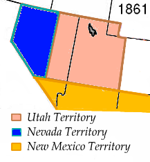
(I wonder if in TLs where the Civil War was a smaller scale thing, Nevada territory just gets split between California and Utah? )
If the argument for population holds (arbitrary) value, the argument for land area must hold similar value. Some regions must therefore be “too big” or “too small” to be states, both in physical size and in population. Does what a given population does with the land they’re allotted (or is able to do with it) factor in, too? Could a sparsely populated region nevertheless become a state thanks to its ability to not be a net tax drain on other states? And perhaps other considerations...Gerrymandering is a hell of a drug.
I'd say the southern part (south of whatever Arizona's northern border parallel is) stays with Arizona, the northern goes to Utah.
That does put the great majority of the state, territory-wise in the hands of Utah, and the Mormons weren't too popular at the time [1]. I'd agree on Arizona, but they might also move the north-south part of the Californian border a bit further east, to include the less-awful-climate bits of western Nevada in California (see this population density map)

[1] Note that they took land from the Utah territory in turning Arizona territory into a state: from Wiki
The Nevada 1861 territory boundary (blue) changed three times: 1864 statehood shifted eastern border from 39th to 38th meridian, 1866 May 5; east border (pink) moved eastward 53.3 mi (85.8 km), from the 38th to 37th meridian, and 1867 January 18; south boundary (yellow) moved from the 37th parallel north southward to the current boundary (14 Stat. 43)[5]
Ethiopia, year 1985. Make note of the neighboring countries.
- Status
- Not open for further replies.
Share: