You are using an out of date browser. It may not display this or other websites correctly.
You should upgrade or use an alternative browser.
You should upgrade or use an alternative browser.
Does Anyone Have Any Map Resources for the Ethnic/Cultural Layout for the Balkans and Anatolia for the 14th/15th Century?
- Thread starter Putnam
- Start date
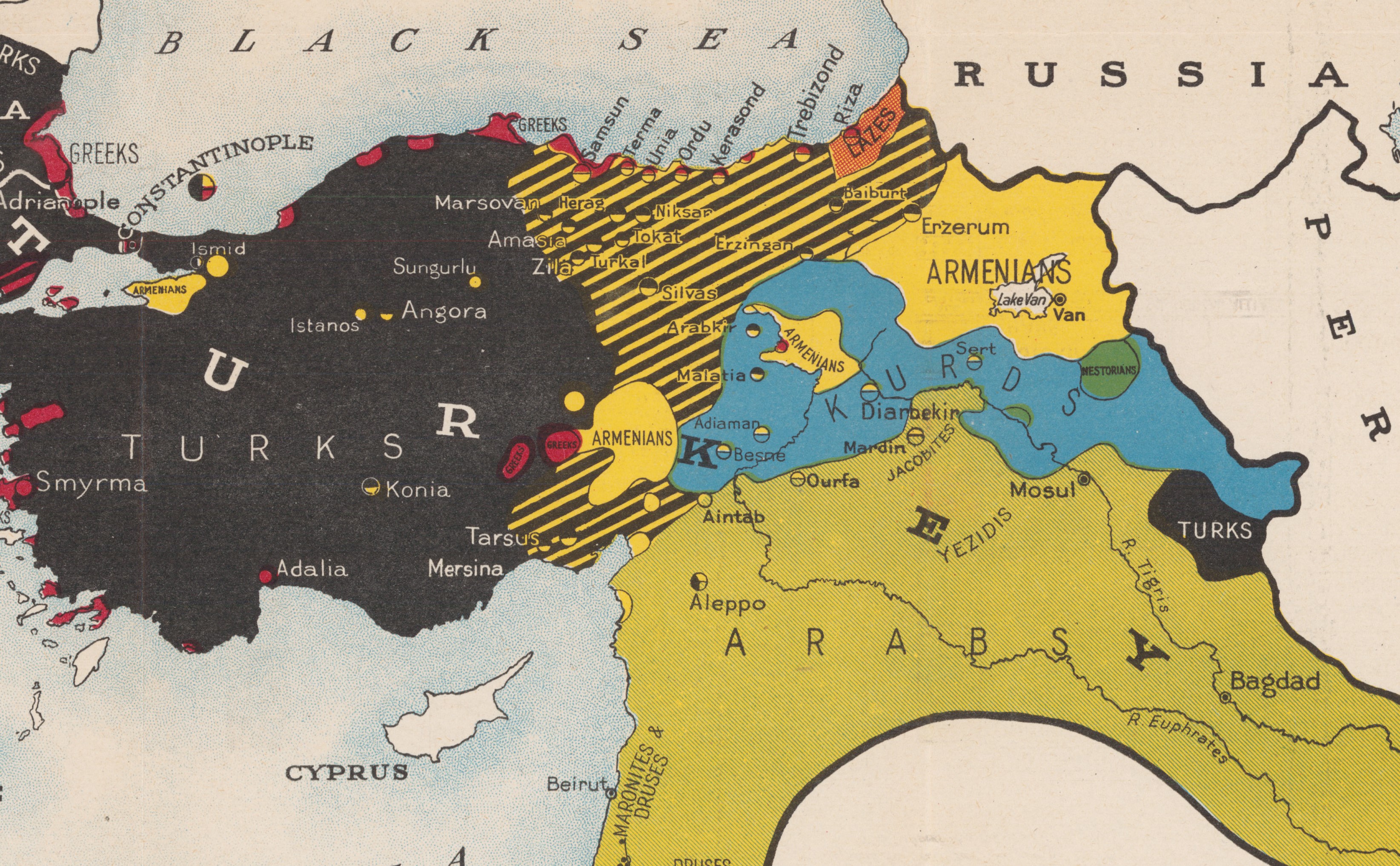
Then would you agree that (Western and Coastal) Anatolia would be ever so slightly more Greek in 1444 AD than in this 1910 AD map? One would think that would be logical, right? Or am I totally off base?I’m not sure the data exists to have a map like that for that period which isn’t completely guesswork and/or ahistorical, no?

The modern concept of ethnicities didn't exist in the same form back then per se. Even as late as the 1900s, in this part of the world especially, things were fluid enough that literal siblings could and did have different answers on censuses, and the same person might answer differently year to year. For a relevant example, for a time, the main thing defining being "Turkish" was just being Muslim. Even Greek speakers who were Muslim were often counted that way in censuses. Conversely, some identified as Greeks due to being Orthodox, even if their home language was Turkish or a Slavic dialect- though the very concept of being Greek isn't fully defined, there are people up to even now who identify as Roman instead or as well. Genetically there's no hard line between Turks and Greeks either way.
For you, this might imply that either the people of the area would have different conceptions of national and ethnic identity and thus use different categories to begin with, or you may just want to map something more concrete like majority religion or language.
For you, this might imply that either the people of the area would have different conceptions of national and ethnic identity and thus use different categories to begin with, or you may just want to map something more concrete like majority religion or language.
Anatolian coastal areas took very significant greek immigration from greece and balkans in the 19th century with the liberalisation of trade and development of the export based economy and ports, just like alexandria in egypt took almost 200.000 greek immigrants.Then would you agree that (Western and Coastal) Anatolia would be ever so slightly more Greek in 1444 AD than in this 1910 AD map? One would think that would be logical, right? Or am I totally off base?


but anything between Ptolemy and 1831 census is a guess
https://en.wikipedia.org/wiki/Demographics_of_the_Ottoman_Empire
Doubtful. Tho culturally the Slavic and Church Slavonic was more widespread as language of diplomacy and religion. Albania and Romania both used it in communications and for naming conventions. The ethnic differences weren’t as pronounced as today. Especially with Ottomans looking large, there was a sort of Christian solidarity of sorts among the local lords.
For Hungary you have this (1495):
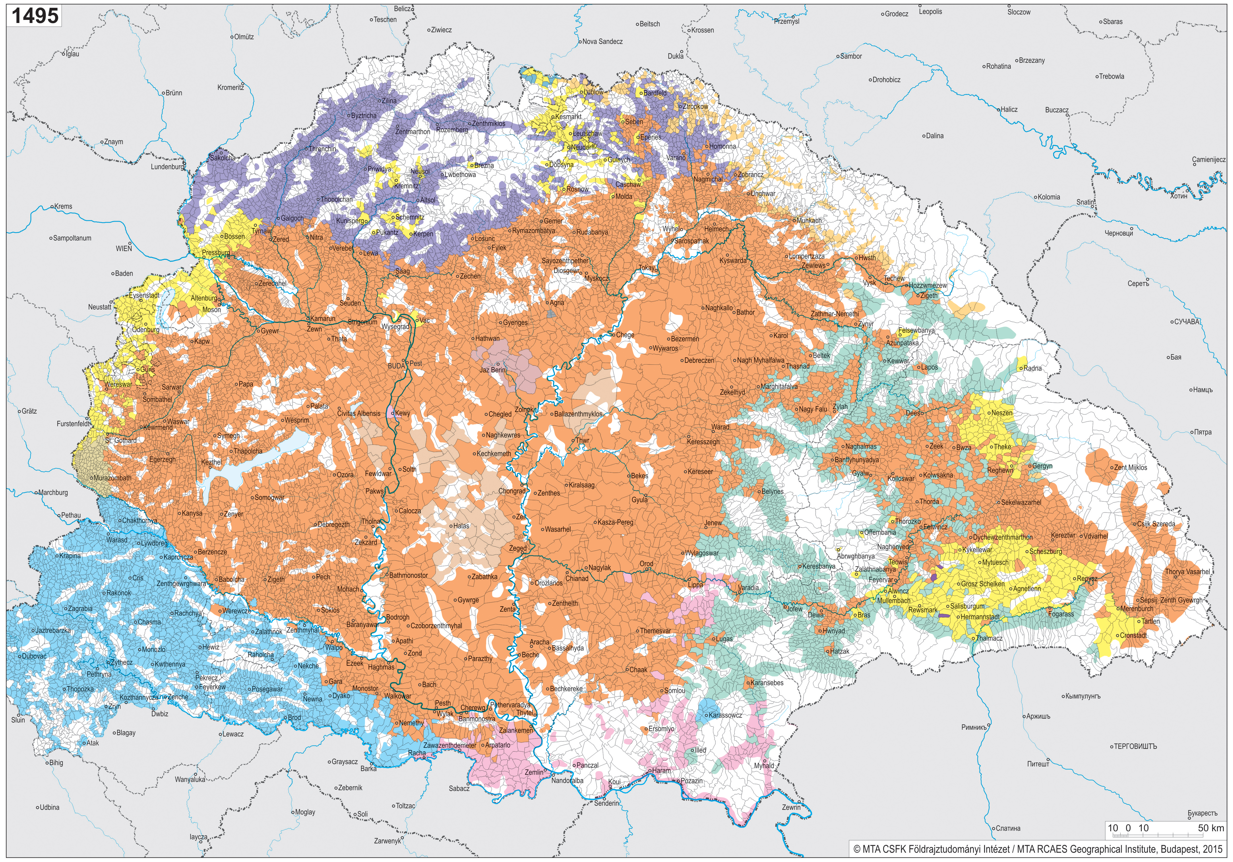
I know its only a part of the region but may be useful.
Furthermore, let's go by areas:
Wallachia and Moldavia were almost entirely Romanian
Dobruja was Bulgarian-Romanian-Gagauz mixed
The area of current Albania was entirely Albanian besides north Epirus which was mixed greek-albanian.
The main issue is placing the extent of Bulgarians and Greeks, because the population movements were continuous: as far as we're concerned, Bulgarians were the majority of the population within modern-day Bulgaria, North Macedonia and the southeast of Serbia. Greeks were the majority in the same areas as in the 19th century maps, adding southern Bulgaria, southern North Macedonia and the Black Sea coasts of Bulgaria, containing them a minority of Bulgarians (approximately, some areas already may have Bulgarian majority).
If you remove the Turks from the 19th century maps, the ethnic makeup isn't much different than it was then.
Last edited:
Share: